Northeast Coastal Ocean Forecast System (NECOFS)
Project Team
Project Lead/Scientific PI: J. Ruairidh Morrison, NERACOOS
Scientific Co-PIs: Chen Changsheng (University of Massachusetts Dartmouth), Joseph Salisbury (University of New Hampshire)
Transition PI: Tom Shyka, NERACOOS
Other Investigators: DMAC POC Riley Young Morse (Gulf of Maine Research Institute), Robert Beardsley (Woods Hole Oceanographic Institution), Alex Prusevich (University of New Hampshire)
NOAA/NOS Technical Points of Contact: Zizang Yang/Edward Myers, Lianyuan Zheng, Audra Luscher, Carolyn Lindley
NOAA/NWI Technical Points of Contact: Trey Flowers, Hassan Mashriqui
Project Overview and Results
The 2016 NOAA Water Initiative Vision and Five-Year Plan promotes a common goal: “To transform water information service delivery to better meet and support evolving societal needs.” The Initiative also identifies flooding and coastal inundation as an area of emphasis. The overarching goal is to effectively deliver improved ocean and coastal inundation forecast products to key end users in the Northeast. To achieve this goal, this project will:
(1) Engage with key end users throughout the project to clearly identify how the information can best be provided to suit their needs, refine the technical approach, and verify that user needs are met.
2) Improve and expand the forecasting capabilities of the Northeast Coastal Ocean Forecast System (NECOFS) and transfer upgraded modeling code, which will help advance coastal ocean modeling, analysis, and prediction for the US Integrated Ocean Observing System (IOOS) and NOAA.
(3) Improve the understanding and prediction of the combined effects of land processes (riverine input/land runoff) and ocean circulation (wind/waves/tides) on coastal inundation in the coastal zone through the implementation and validation of coupled hydrologic cycles models and ocean circulation models.
The improved forecasting of Northeast ocean conditions and coastal inundation will directly benefit National Weather Service (NWS) marine forecasters and regional coastal emergency managers. These user groups will be directly involved in the project to ensure that the improved forecasting capabilities meet their needs and are effectively delivered to them. This project will also result in a new version of the Finite Volume Community Ocean Model (FVCOM), which has been adopted by NOAA’s CO-OPS and is used by hundreds of researchers around the world.
Model Descriptions
NECOFS:
NECOFS is an integrated regional atmosphere/surface wave/ocean forecast model system, covering the Delaware Shelf to the eastern end of the Scotian Shelf. NERACOOS and IOOS have supported the operations and improvement of NECOFS since 2007. The present system includes: 1) a community mesoscale meteorological model, Weather Research and Forecasting (WRF); 2) the 4th regional version of the Finite Volume Community Ocean Model (GOM4-FVCOM); 3) the unstructured-grid surface wave model (GOM4-SWAVE) modified from SWAN (Qi et al., 2009); 4) the Massachusetts (Mass) Coastal FVCOM with the inclusion of estuaries, inlets, harbors and intertidal wetlands; and 5) four subdomain wave-current coupled FVCOM inundation forecast systems in Scituate and Boston Harbor, MA; Hampton-Seabrook Estuary, NH, and Saco Bay, ME (Figure 1).
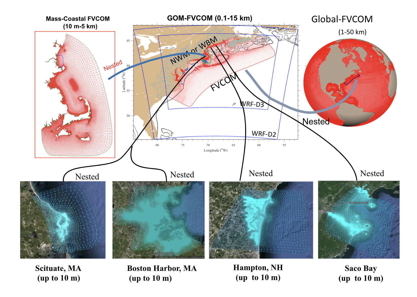
Figure 1. Schematic chart of the NERACOOS supported Northeast Coastal Ocean Forecast System (NECOFS).
NECOFS is forced by 1) the surface wind, wind stress, heat flux and precipitation minus evaporation flux; 2) measured river discharge along the coastal boundary; 3) surface waves and tides along the ocean boundary; 4) the inflow of the cool and lower salinity water from the upstream Scotian Shelf; and 5) along the outer ocean boundary by the Global-FVCOM, which allows the interaction with the Gulf Stream as well as data assimilation of SST, SSH and T/S profiles for the NECOFS domain covering the entire Northeast coastal region.
As an initial component of a state-of-the art “end-to-end” model forecast system for NERACOOS, NECOFS was placed in experimental forecast operation in late 2007, making daily experimental three-day forecast of surface winds, air pressure, precipitation via evaporation, wintertime icing, water elevation, 3-D water currents, water temperature and salinity, significant wave height/frequency, and storm-induced coastal inundation for the Northeast US coastal region. The forecast operation was carried out daily with an updated initial condition that is determined by the three-day backward hindcast or nowcast data assimilation. The data used in the data assimilation includes satellite SST and radiation, river discharge, NOAA C-MAN and NDBC buoys, and NERACOOS buoys. A web-based mapping application was developed to display the NECOFS forecast products (via WMS services) for public use, which can be accessed at the address: http://134.88.228.119:8080/fvcomwms/. Additionally, NECOFS data are accessible via web services from a THREDDS Data Server (TDS) housed at University of Massachusetts – Dartmouth (UMassD) and integrated into several NERACOOS.org data products, including a model/observation comparison tool and a recently developed coastal flood forecast tool.
The present version of NECOFS has two versions: 1) forecast version, and 2) hindcast version. Both forecast and hindcast versions use the same regional domain grid, but the forecast version does not include the nesting boundary with global models and has a maximum water depth of 1500 m. The hindcast version is a global-regional nested system with the boundary conditions provided by Global-FVCOM.
Hindcasts produced by NECOFS successfully capture the spatial and temporal variability of the physical field in the region including: vertical mixing and subtidal currents (Cowles et al., 2008); tidal elevations/currents (Chen et al., 2011); water stratification (Li et al., 2015); CODAR-derived surface currents (Sun et al., 2016); and the upstream region in the Arctic Ocean (Chen et al. 2016, Zhang et al., 2016a,b).
The current NECOFS system is at a Readiness Level (RL) of 7, since it has been demonstrated in an operational environment. This project will advance NECOFS to a RL of 9 for the Northeast Region. However, one of the main focus areas of this project is to upgrade various components of NECOFS that are currently at a RL of 4-5 to a RL of 7-8. The Finite Volume Community Ocean Model Community (FVCOM), at the core of NECOFS, has been developed and upgraded by the UMassD team since 1999 (Chen et al., 2003, 2006, 2013). It features unstructured triangular meshes with horizontal resolution of ~ 0.1-25 km and a hybrid terrain-following vertical coordinates. The most recent version of FVCOM (version-4) is a fully coupled current-ice-wave-sediment-ecosystem model system. FVCOM version-5 is in development and currently at a RL of 5, since it has undergone successful evaluation in a relevant environment. This project will advance FVCOM version-5 to a RL of 8.
Global-FVCOM is a fully atmosphere-ice-surface wave-ocean coupled primitive equation unstructured-grid ocean model that was also developed by UMassD. Global FVCOM is driven by astronomical tidal forcing with eight constituents (M2, S2, N2, K2, K1, P1, O1 and Q1); surface wind stress; net heat flux at the surface plus shortwave irradiance in the water column; surface air pressure gradients; precipitation (P) minus evaporation (E); and river discharge (Gao et al., 2011, Chen et al., 2016). The updated version of Global-FVCOM features a horizontal resolution of ~2 km (measured by the length of the longest edge of a triangular cell) within the Canadian Archipelago, shelf-break and coastal regions to ~50 km in the interior open ocean. The vertical grid features a total of 45 layers (Chen et al., 2009, 2016). In shelf and coastal regions of depth less than 225 m, a sigma distribution with a uniform layer thickness is used. The coordinate transition thus occurs smoothly at a depth of 225 m, where all layers have a uniform thickness of 5 m.
The Advanced Research Weather Research Forecast model (ARW-WRF):
With support from the NOAA Cooperative Institute for the North Atlantic Region, in the wake of the Sandy Superstorm, the present version of NECOFS was used to examine the influence of oceanic mixed layer (OML) dynamics, cumulus parameterization, atmospheric planetary boundary layer schemes, grid design/resolution on intensity, pathway and landfall of Hurricane Sandy (Li et al., 2017). Including the OML parameterization was shown to significantly improve the accuracy of the simulated hurricane pathway and the intensity of the minimum central sea level pressure. OML parameterization was included in NECOFS through coupling the Advanced Research Weather Forecast model (ARW-WRF) into NECOFS and conducting the hurricane simulation for the cases with and without coupling of the OML. The reality and accuracy of hurricane path and intensity were also found to be relevant to the design and resolution of the two-way nested grid. To improve the NECOFS’ capability for hurricane forecast and storm induced coastal inundation, it is necessary to upgrade the NECOFS into a fully coupled atmospheric-oceanic model system. Improving the domain covering the region of the early development stage of the hurricane and grid refinement in the coastal region could also improve the simulation results of hurricane center pathway, timing and intensity. The NECOFS with the AWR-WRF has undergone successful evaluation in an experimental environment and is at a RL of 4.
Extended and higher Resolution Domain - GOM5-FVCOM
An expanded and higher resolution grid domain, GOM5-FVCOM, has been developed with a southward extended domain to Cape Hatteras. The new grid domain will improve the ability to investigate coastal inundation, as well as provide an increased understanding of changes in the connectivity of the fish larvae recruitment, coastal acidification, and ecosystems over the entire Northeast coastal ocean. The GOM5-FVCOM domain has undergone successful evaluation in relevant environment through testing and prototyping and is at a RL of 5.
References
Chen, C., H. Liu, and R. Beardsley, 2003. An unstructured grid, finite-volume, three-dimensional, primitive equations ocean model: Application to coastal ocean and estuaries. Journal of Atmospheric and Ocean Technology, 20(1), 159–186.
Chen, C, R. C. Beardsley, and G. Cowles, 2006. An unstructured grid, finite-volume coastal ocean model (FVCOM) system. Special Issue entitled “Advance in Computational Oceanography”, Oceanography, 19(1), 78- 89.
Chen, C., G. Gao, J. Qi, A. Proshutinsky, R. C. Beardsley, Z. Kowalik, H. Lin, G. Cowles, 2009. A new high-resolution unstructured-grid finite-volume Arctic Ocean model (AO-FVCOM): an application for tidal studies. J. Geophys. Res., 114, C08017, doi: 10.1029/2008jc004941.
Chen, C., H. Huang, R. C. Beardsley, Q. Xu, R. Limeburner, G. W. Cowles, Y. Sun, J. Qi and H. Lin, 2011. Tidal dynamics in the Gulf of Maine and New England Shelf: An application of FVCOM. J. Geophys. Res., 116, C12010, doi: 10.1029/2011JC007054.
Chen, C., R. C. Beardsley, G. Cowles, J. Qi, Z. Lai, G. Gao, D. Stuebe, H. Liu, Q. Xu, P. Xue, J. Ge, R. Ji, S. Hu, R. Tian, H. Huang, L. Wu, H. Lin, Y. Sun, and L. Zhao, 2013. An unstructured-grid, finite-volume community ocean model FVCOM user manual (3rd edition), SMAST/UMASSD Technical Report-13-0701, University of Massachusetts-Dartmouth, p 404.
Chen, C., G. Gao, Y. Zhang, R. C. Beardsley, Z. Lai, J. Qi, H. Lin, 2016. Circulation in the Arctic Ocean: Results from a high-resolution coupled ice-sea nested Global-FVCOM and Arctic-FVCOM system. Prog. Oceanogr. 141, 60-80, doi: 10.1016/j.pocean.2015.12.002.
Cowles, G., S. J. Lentz, C. Chen, Q. Xu, and R.C. Beardsley, 2008. Comparison of observed and model-computed low frequency circulation and hydrography on the New England Shelf, Journal of Geophysical Research, 113, C09015, doi:10.1029/2007JC004394.
Gao, G., C. Chen, J. Qi, and R. C. Beardsley, 2011. An unstructured-grid, finite-volume sea ice model: Development, validation, and application, J. Geophys. Res., 116, C00D04, doi:10.1029/2010JC006688.
Li, Y, P. S. Fratantoni, C. Chen, J. Hare, Y. Sun, R. C. Beardsley, and R. Ji, 2015. Spatia-temporal patterns of stratification on the Northwest Atlantic shelf. Prog.
Li, S., Chen, C., Wu, Z Beardsley, R. C. and Li, M., 2017. Impacts of Ocean Dynamics and Parameterizations on Hurricane Simulation: An Experiment for Hurricane Sandy with ARW. Monthly Weather Review, submitted.
Sun, Yunfang, C. Chen, R. C. Beardsley, D. Ullman, B. Butman, H. Lin. 2016. Surface circulation in Block Island Sound and adjacent coastal and shelf regions: A FVCOM-CODAR comparison. Prog. Oceanogr., 143, 26–45.
Zhang, Y., C. Chen, R. C. Beardsley, G. Gao, J. Qi, and H. Lin, 2016a. Seasonal and interannual variability of the Arctic sea ice: A comparison between AO-FVCOM and observations. J. Geophys. Res., 10.1002/2016JC011841, 31.
Zhang, Y., C. Chen, R. C. Beardsley, G. Gao, Z. Lai, B. Curry, C. M. Lee, H. Lin, J. Qi, and Q. Xu, 2016b. Studies of the Canadian Arctic Archipelago water transport and its relationship to basin-local forcings: Results from AO-FVCOM. J. Geophys. Res., 10.1002/2016JC011634, 24.