Chesapeake Bay Environmental Forecasting System
Project Team
Lead Principal Investigator: Dr. Marjorie Friedrichs, Research Professor, Virginia Institute of Marine Science
Financial Representative: Connie Motley, Director, Office of Sponsored Programs, Virginia Institute of Marine Science
Funding Type: Cooperative Agreement
Applicant Type: Public/State Controlled Institution of Higher Education
Principal Investigators: Dr. Marjorie Friedrichs (Scientific PI), Virginia Institute of Marine Science, Dr. Gerhard Kuska (Transition PI), MARACOOS, Dr. Raleigh Hood, University of Maryland Center for Environmental Science, Dr. Christopher Brown, NOAA/NESDIS, Dr. John Jacobs, NOAA/NCCOS
Additional Partners: Dr. Patrick Burke, NOAA/NOS, Chief, Oceanographic Division, Dr. Aaron Bever, Anchor QEA, Managing Scientist, Dr. Pierre St-Laurent, VIMS, Research Scientist, Kelly Knee, RPS North America, Executive Director, Ocean Science, Susanna Musick, VIMS, Marine Recreation & Fisheries Extension Specialist, Karen Hudson, VIMS, Shellfish Aquaculture Extension Specialist
Project Overview and Results
The overarching goals of this proposal are to (1) advance the development of forecasts for harmful algal blooms (HABs) and pathogens in the Chesapeake Bay, and (2) accelerate the transition of these forecasts from a research environment to an integrated operational system with MARACOOS (the Mid-Atlantic Regional Association Coastal Ocean Observing System) and their partners within the National Centers for Coastal Ocean Science (NCCOS). The Center for Operational Oceanographic Products and Services (CO-OPS) is committed to helping facilitate the latter by engaging with the team to improve understanding of National Ocean Service (NOS) requirements for potentially transitioning the modeling system to operations within NOAA.
Our existing Chesapeake Bay Environmental Forecasting System (CBEFS; vims.edu/hypoxia) is based on an open-source community model (an implementation of the Regional Ocean Modeling System) and provides nowcasts and forecasts of salinity, temperature, hypoxia, and pH. Input from our Stakeholder Focus Group meetings has revealed that these forecasts have proven very useful to end-users whose livelihoods depend on the Chesapeake Bay: information on hypoxia helps guide anglers to productive fishing grounds and information on pH can help aquaculturists and oyster hatchery operators decide when to delay spawning and avoid supplying spawning tanks with Bay intake water when water quality is poor. However, feedback from these stakeholders and local managers indicates that they require additional information including nowcasts and forecasts of harmful biotic events, so they can assess health threats and make decisions on beach closures or avoid harvesting shellfish when HABs are present.
Based on this feedback, we propose a multi-faceted effort that will (1) address multiple coastal modeling challenges with a new high-resolution version of CBEFS resulting in improved forecasts of our primary environmental variables, (2) use output from CBEFS to improve, validate, and verify the utility of existing Vibrio and HAB habitat suitability models, thus specifically providing the additional forecasts that have been directly requested by our stakeholders and (3) establish a prototype alert system that will send automated alerts when thresholds for the probable occurrence of these noxious organisms are present. All model results will be quantitatively evaluated via comparison with independent cruise and mooring data, and skill will be compared to the existing Chesapeake Bay Operational Forecast System (CBOFS) and with our previous COMT implementations. To ensure end users are inherently involved in the continuing development and design of our operational management tools, we will work in partnership with extension specialists to continue conducting Stakeholder Focus Group meetings to receive feedback on the format and content of the forecasts directly from our end users. Continuing to work closely with our operational hosts at MARACOOS, NCCOS and NOS will ensure that our forecasts are transitioned to operational readiness in a timely and efficient manner.
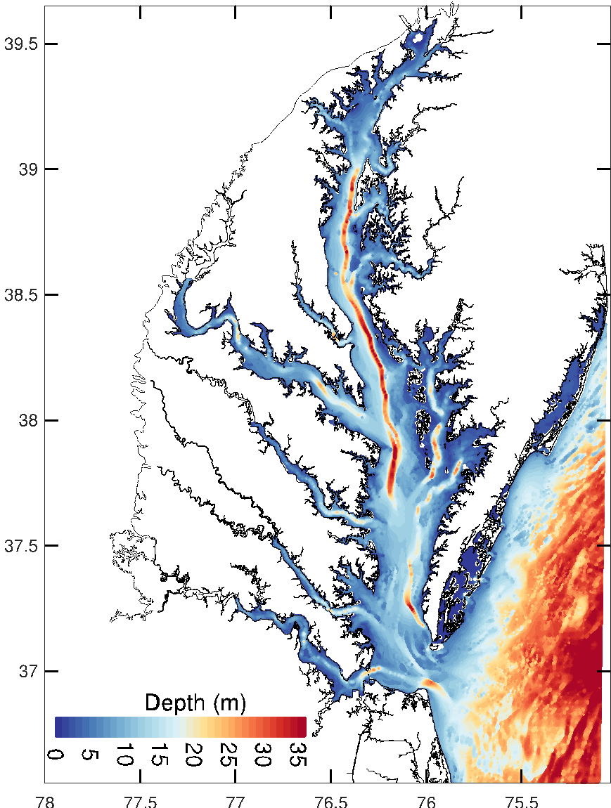
Figure 1: New high-resolution version of CBEFS; forecasts of T, S, O, and pH using this new grid is available on MARACOOS’ OceansMap; see: http://nordet.net/chesapeake_bay.html for animation.
References
Bever, A.J., M.A.M. Friedrichs, P. St-Laurent, 2021. Real-time environmental forecasts of the Chesapeake Bay: Model setup, improvements, and online visualization. Environmental Modelling and Software, 105036, https://doi.org/10.1016/j.envsoft.2021.105036